Numerous short-lived tornadoes confirmed from Friday morning’s storms
OMAHA, Neb. (WOWT) - The round of storms early Friday morning woke many people up around 1 or 2 a.m. as over a dozen tornado warnings were issued across the area. The powerful line of storms marching across the region left behind over 100 wind damage reports with winds gusting over 80 mph in several locations.
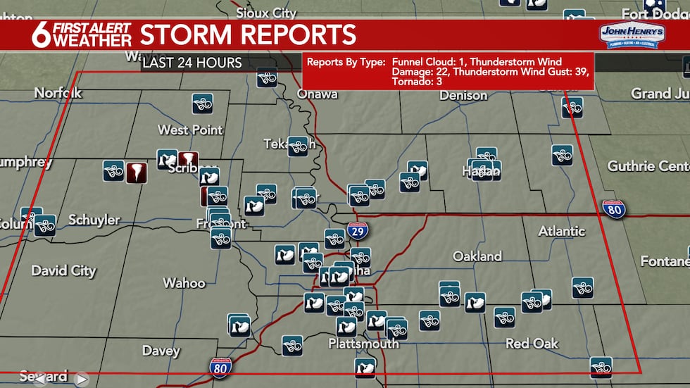
In addition to the damaging winds experienced by many, the National Weather Service has now confirmed 12 tornadoes touched down Friday morning with that line of powerful storms that moved through before 3 a.m. All of the tornadoes so far have been rated as EF-0, with wind speeds of 65 to 85 mph.
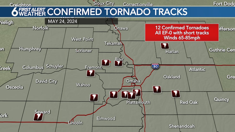
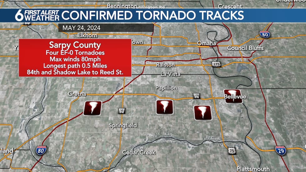
Four of those tornadoes touched down in Sarpy County, with very short paths in Gretna, Papillion, and Bellevue. The strongest tornado in Sarpy touched down near 84th and Shadow Lake, lifting a half-mile later near Reed Street. Maximum winds were estimated to be around 80 mph. The most long-lived tornado touched down in central Washington County west of Blair and was on the ground for three miles with winds up to 80 miles per hour.
Most of the damage was limited to broken tree limbs, with some uprooted trees. There was damage to a few homes as branches or trees fell onto roofs, along with thousands of power outages. Storm surveys are ongoing and additional tornado touchdowns may be identified across portions of Dodge, Colfax, and Platte counties in the days to come.
You can find the full details on all of the reported tornadoes from the National Weather Service Below:
..Seward County Tornado...
Rating: EF0
Estimated Peak Wind: 70 mph
Path Length /statute/: 0.04 miles
Path Width /maximum/: 20 yards
Start Time: 01:43 AM CDT
Start Location: 4 SSW Seward / Seward County / NE
End Time: 01:43 AM CDT
End Lat/Lon: 40.8551 / -97.1175
Survey Summary:
This tornado was a very brief spin up causing little damage to a center pivot.
..Woodcliff Lake Tornado...
Rating: EF0
Estimated Peak Wind: 75 mph
Path Length /statute/: 0.00 miles
Path Width /maximum/: 20 yards
Start Location: 2 SSE Inglewood / Saunders County / NE
End Time: 02:03 AM CDT
Survey Summary:
This was a very brief spin-up tornado that caused tree damage at Woodcliff Lake community.
..Memphis Tornado...
Rating: EF0
Estimated Peak Wind: 76 mph
Path Length /statute/: 0.09 miles
Path Width /maximum/: 60 yards
Start Time: 02:12 AM CDT
Start Location: 2 SE Memphis / Saunders County / NE
End Time: 02:12 AM CDT
Survey Summary:
This tornado was a brief spin-up creating damage to trees and powerlines.
..Washington County Tornado...
Rating: EF0
Estimated Peak Wind: 80 mph
Path Length /statute/: 3.37 miles
Path Width /maximum/: 60 yards
Start Time: 02:18 AM CDT
Start Location: 6 NNE Arlington / Washington County / NE
End Time: 02:20 AM CDT
End Location: 5 NNW Kennard / Washington County / NE
Survey Summary:
This very brief tornado caused damage to several trees and power poles.
..Blair Tornado...
Rating: EF0
Estimated Peak Wind: 74 mph
Path Length /statute/: 1.46 miles
Path Width /maximum/: 60 yards
Start Time: 02:22 AM CDT
Start Location: 2 SSW Blair / Washington County / NE
End Time: 02:22 AM CDT
End Location: Blair / Washington County / NE
Survey Summary:
Very brief tornado touchdown causing significant tree damage across portions of Blair.
..South Gretna Tornado...
Rating: EF0
Estimated Peak Wind: 79 mph
Path Length /statute/: 0.15 miles
Path Width /maximum/: 50 yards
Start Time: 02:25 AM CDT
Start Location: 2 SE Gretna / Sarpy County / NE
End Time: 02:25 AM CDT
Survey Summary:
This very brief spin-up tornado damaged several powerpoles.
..Shadow Lake Tornado...
Rating: EF0
Estimated Peak Wind: 79 mph
Path Length /statute/: 0.48 miles
Path Width /maximum/: 60 yards
Start Time: 02:31 AM CDT
Start Location: 2 S Papillion / Sarpy County / NE
End Time: 02:32 AM CDT
Survey Summary:
This very brief tornado near Shadow Lake Elementary produced minor damage to homes and damaged numerous trees in the neighborhood. Some fences were also damaged.
..Bellevue Tornado...
Rating: EF0
Estimated Peak Wind: 74 mph
Path Length /statute/: 0.02 miles
Path Width /maximum/: 40 yards
Start Time: 02:35 AM CDT
Start Location: 2 W Offutt AFB / Sarpy County / NE
End Time: 02:35 AM CDT
Survey Summary:
This brief spin-up tornado caused tree damage to a few properties.
..Old Towne Bellevue Tornado...
Rating: EF0
Estimated Peak Wind: 74 mph
Path Length /statute/: 0.04 miles
Path Width /maximum/: 50 yards
Start Time: 02:41 AM CDT
Start Location: 2 SE Bellevue / Sarpy County / NE
End Time: 02:41 AM CDT
..South of Treynor Tornado...
Rating: EF0
Estimated Peak Wind: 83 mph
Path Length /statute/: 0.25 miles
Path Width /maximum/: 60 yards
Start Time: 03:00 AM CDT
Start Location: 4 S Treynor / Pottawattamie County / IA
End Time: 03:01 AM CDT
Survey Summary:
This very brief spin up remained near Aspen Road and 300th street south of Treynor. Three grain bins were destroyed as well as numerous trees.
..Henderson Tornado...
Rating: EF0
Estimated Peak Wind: 74 mph
Path Length /statute/: 2.09 miles
Path Width /maximum/: 60 yards
Start Time: 03:10 AM CDT
Start Location: 3 E Henderson / Montgomery County / IA
End Time: 03:10 AM CDT
End Location: 4 ENE Henderson / Montgomery County / IA
Survey Summary:
This brief spin up tornado damaged trees at a farmstead as well as outbuildings.
..Westphalia/Earling Tornado...
Rating: EF0
Estimated Peak Wind: 80 mph
Path Length /statute/: 0.09 miles
Path Width /maximum/: 40 yards
Start Time: 03:13 AM CDT
Start Location: 2 N Westphalia / Shelby County / IA
End Time: 03:13 AM CDT
Survey Summary:
This brief spin-up tornado damaged roofs off an outbuilding and downed several trees.
Copyright 2024 WOWT. All rights reserved.


