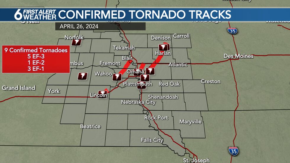
TORNADO SURVEY: National Weather Service issues first official report on Friday’s storm
At least 9 tornadoes confirmed with 5 significant EF-3 tornado paths identified
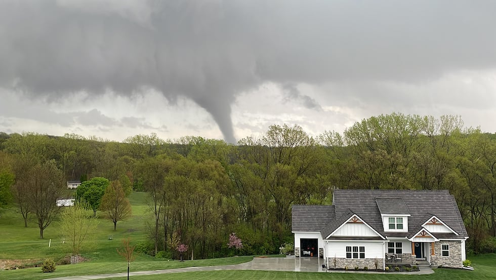
OMAHA, Neb. (WOWT) - An outbreak of destructive tornadoes struck eastern Nebraska and western Iowa on Friday, leaving long swaths of devastation.
The National Weather Service has spent the last several days reviewing the damage to piece together the storm paths and intensity as they ripped through the area. So far 9 tornadoes have been confirmed, with 5 of those being extremely destructive EF-3 tornadoes. Survey efforts remain ongoing across the area.
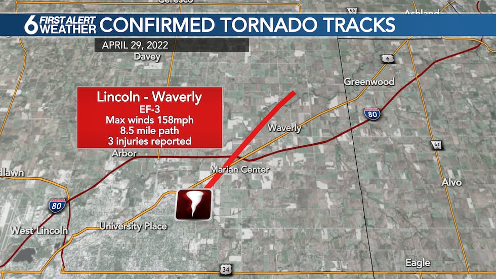
The first major tornado of the day touched down on the northeast side of Lincoln around 2:40 p.m., right along Highway 6 and damaged several industrial buildings before crossing I-80 and flipping several vehicles and passing west of Waverly, Neb.
The tornado was on the ground for over 8 miles before lifting just before reaching Greenwood Drive to the west of Greenwood in Lancaster County. Damage along the path of the tornado indicated wind speeds of nearly 160mph making it an EF-3 storm according to the National Weather Service.
After dissipating, that same storm system went on to produce a new tornado around 3:30 p.m., touching down near 264th and Q Street in far southwest Douglas County, quickly moving into southwest Omaha. The tornado crossed Center Street near 252nd, just south of West Shores Lake.
The storm then crossed West Dodge just east of Highway 275 and moved into far western Elkhorn, becoming a very destructive tornado, damaging and destroying dozens of homes either side of 216th Street. Here the tornado was rated EF-3, leaving several homes with little more than a few walls standing.

The tornado continued to move to the north and east, crossing Rainwood Road and Military Road near 180th Street before moving into the Bennington Lakes area where dozens more homes were severely damaged. The circulation intensified as the storm tracked into Washington County, crossing Highway 133 just north of the Blair Airport and damaging a neighborhood north of the Lake Arrowhead Reservoir.
The tornado continued to the southeast side of Blair, impacting an industrial area before crossing the Missouri River and dissipating just before reaching Modale. In total, the the tornado was on the ground for just over 31 miles with maximum winds around 165mph making it a high end EF-3 tornado. Additional assessments are ongoing and some adjustments may be made in the days ahead.
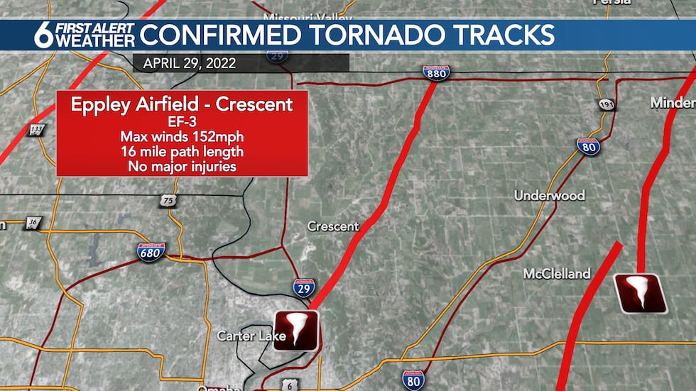
Another tornado developed right near downtown Omaha just before 5 p.m. This tornado developed right over Eppley Airfield, damaging parts of the airport, forcing a temporary closure. The tornado then quickly crossed the Missouri River into Iowa, and crossed I-29 north of Council Bluffs. The circulation made a direct line toward one of our city cams before the connection was lost due to damage in the area.
The tornado then continued across northwestern Pottawattamie County, passing just east of Crescent, and then crossed I-880 just west of Exit 21 near with reports of damage in the area. The tornado finally dissipated just after crossing into Harrison County. The tornado was on the ground for a little over 16 miles with maximum winds around 150mph making it an EF-3 storm.
Yet another tornado developed near Pacific Junction just around 4:50 p.m. Damage was reported to the north of town, just west of Glenwood, with the tornado then quickly dissipating. The tornado was on the ground for nearly 3 miles with max winds around 100mph making it an EF-1 storm.
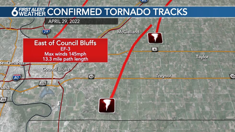
However, that same storm cycled and a new tornado developed about 10 minutes just north of the Pottawattamie and Mills County lines to the northwest of Mineola. This tornado quickly intensified, becoming a destructive storm as it moved into central Pottawattamie County crossing Highway 92 just west of Treynor.
A home suffered major damage along the highway as the storm push north toward Cottonwood Road, damaging several more homes. The tornado dissipated just to the east of McClelland, having been on the ground for just over 13 miles with maximum winds of 145mph making it an EF-3 storm.
A new, large, multi-vortex tornado then quickly developed from the same storm in the same area just east of McClelland. The tornado quickly became extremely destructive, damaging or destroying dozens of homes in Minden, IA.
The tornado then crossed I-80 a few miles east of the I-880 interchange, and moved into Shelby County where it remained on the ground doing damage. The multi-vortex tornado continued toward Tennant, and then crossed Highway 44 west of Harlan, and Highway 59 north of Harlan as a large and destructive storm.

Possible satellite tornadoes were reported at times, though any paths or damage associated with those smaller tornadoes have not yet been identified. The tornado moved almost due north from Harlan and passed just to the east of Defiance, IA before finally dissipating.
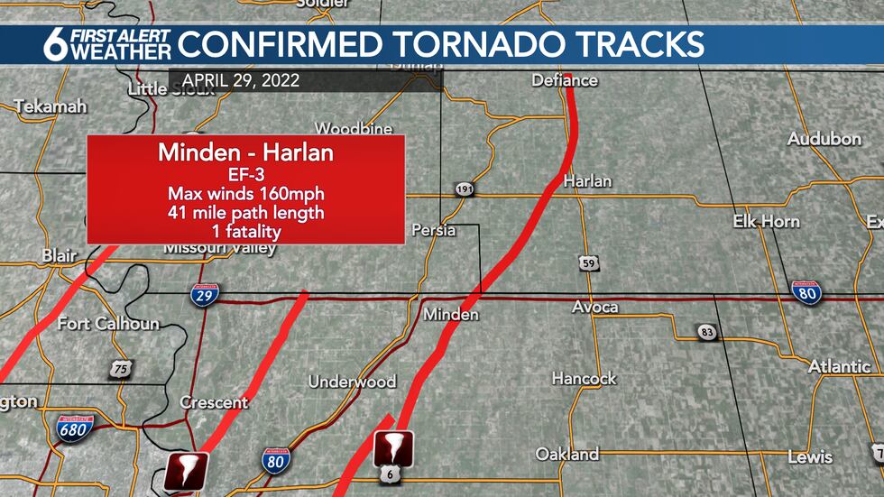
This major tornado was on the ground for nearly 41 miles with maximum winds around 160mph, making it the fifth EF-3 tornado of the day.
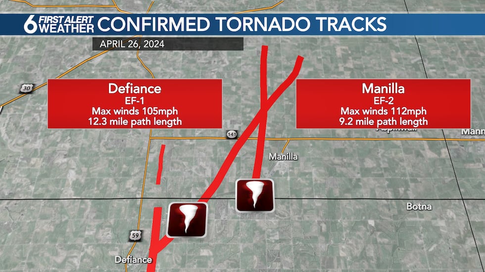
Two additional tornadoes developed in or just east of Defiance, IA about an hour later. These tornadoes were rated EF-1 and EF-2 respectively, with path lengths between 9 and 12 miles. Wind speeds reached up to 112mph, damaging several buildings and homes between Defiance and Manilla, IA.
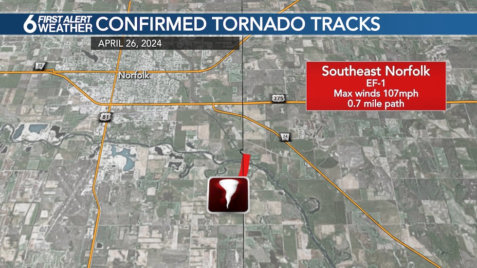
A brief tornado was also reported just to the southeast of Norfolk, crossing the Madison and Stanton county lines. The tornado was on the ground for less than a mile, but damaged a gymnastics gym and a pallet plant. Maximum winds approached 107mph, making it an EF-1 tornado.
Additional tornadoes were reported in Butler and Platte Counties in Nebraska, but track details have yet to be finalized on those storms.
Copyright 2024 WOWT. All rights reserved.


